Unlocking the power of Digital Soil Maps
A modern production and/or environmental landscape planning cannot disregard the use of Digital Soil Maps. The physical-chemical degradation and loss of fertility of cultivated soils represent the main challenges of the coming years.
The effectiveness of planned interventions is closely tied to the availability of accurate and up-to-date information.
Revolutionizing Sustainability
We create processing chains and biophysical models for generating digital maps of the soil’s surface layer, with applications already validated for arable land.
Here are some of the parameters we analyse:
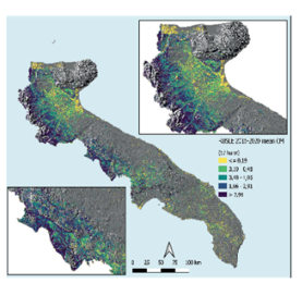
Surface soil erosion
Cation exchange capacity
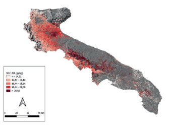
Organic carbon
Texture (% clay, sand, silt)
Nitrogen, phosphorus, potassium
Organic matter
pH
Electrical conductivity
Soil erosion maps and organic carbon maps are essential tools for territorial control by any public administration, but they also provide valuable support to commercial sectors. These sectors can not only understand where and how to cultivate better, but also steer their production processes towards more sustainable practices.
Soil Mapping
We bring innovation to the field by integrating and interconnecting advanced technologies.